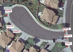
The Mobile Mapper 6 is the generation that came to replace the CX and Pro, which produced Magellan time ago. Today we will see how to capture field data. 1. Basic configurations. To capture data, the equipment must have installed the Mobile Mapping software that comes with the discs when purchasing your computer and is installed via Active Sync. To ...
Read More »cadastre
Preparing for the course on ArcGIS
A little less than a week I start to feel the stress of an ArcGIS course, those who emerge no one knows where, you accept without knowing when, and that suddenly you’re committed in. It’s a group of enthusiasts who don’t want to complicate with the unknown software, which have money and expect to integrate ArcGIS. For a moment I ...
Read More »Generating contours with ArcGIS
Making land surveying with a total station, apart from having pinpoint accuracy, it also may be useful for other purposes, given that you have the elevation of each point. In this case, let’s see how generate contour, which was already sawn with AutoDesk Civil 3D, Bentley Geopak and Manifold GIS, so for educational purposes, in this case we will do ...
Read More »2 egeomates on the fly and 6 links
Long trip, for three days I have been touring with succulent creoles meals. Finally back, many unread mails and the new 12.2-megapixel Kodak camera going very well. Here I leave some readings and news of interest: Bentley extends interoperability to FME. Very interesting, Bentley Map has integrated the chance of interacting data via ETL from Safe Software. With this, it ...
Read More »CAD, GIS… or both?
… Selling capabilities of what free software does is more difficult than to convince an official to commit a felony punishable (piracy) for what expensive software doesn’t do. Bentley has recently launched a campaign to promote Bentley Map, using as an argument, it is not necessary to be thinking separately if they can be handled by a single tool. On ...
Read More »Bentley Cadastre: differences with Bentley Map and Power Map
From MicroStation Geographics in 2004 it was launched the project known as XFM, which within the same V8 dgn format included XML capabilities. After the 8.9 version known as XM Bentley discontinued, Geographics launches Bentley Map, a different smoked regarding the handling of data, but with the same logic operation. Migrating is now indisputable, for this I make the difference ...
Read More »Connect AutoCAD Google Earth
A common desire to AutoCAD user is connecting to Google Earth, so as to be able to work on the image that toy has, but its accuracy is questionable, every day we find better material but it is useful rather than having nothing. Today we will see at least two alternatives to do so: A. With the ImportGEImage command This ...
Read More »Caceres’ GIS
This is one of the projects that became a finalist for the award of the Be Inspired 2009 in the category of Cadastre and Land Development. They also made a presentation which was in charge of Luis Antonio Alvarez and Faustino Cordero, with a very good PPS presentation, videos and also a printed map. The day of the award I ...
Read More »On a journey, preparing a video
I have spent almost a week away, in a complementary work to the systematic process that involves shooting a video that must rescue the essence of the methodology applied. This shooting task is an interesting world, I mean the lightning play, the recreation of past scenarios, capturing events that are still alive, the handling of the interview, abstraction, concretion, finally ...
Read More »Me, Cadastre and Google Earth
I have just returned from my trip, it has been lived between folk meals, the pressure of the qualifying rounds for the football world cup and work’s satisfactions; so, here I leave an extract from some unforgettable phrases of our daily job. The consultants: -¡Hurry Up! -dialog cleanup!The draftsmen: -Uff!!! When will the paying be? The appraisers: -It’s better not ...
Read More »Finalists for the 2009 Be Inspired
I’ve been invited to cover the Charlotte event, which awards prizes to the most significant innovation projects for the 2009, formerly known as Be Awards, now Be Inspired. This will take place from October 12th to 14th. From the 17 Categories, it interests me the Cadastre and Territorial Development, for which already have been appointed as finalists: 1.Caceres’ GIS in ...
Read More »Convert images to vector
Some time ago, the digitizing tables were the output for vectorizing print maps; then the scanner arrived to the office, although the task does not just apply to scanned maps, but for others that were converted to image or pdf and for the ones which we don’t have vector format. The procedure that I am going to show will use ...
Read More »A standard model for the cadastre
This name has a paper presented at the Third ISDE Congress held in the Czech Republic in 2003. The authors, all of the ITC and the Geodesy Department of the technology Delft University, of the Netherlands. Although the link I show (in English) has some additional adjustments Christiaan Lemmen Paul Van Der Molen Peter Van Oosterom Hendrik Ploeger Wilko Quak ...
Read More »MobileMapper 6 vrs. Juno SC
I told you that I’m testing the MobileMapper 6, on this week we will do field test, but reading online I found that earlier on this year it was written an article based on a comparison test of these two instruments, here I’ll show the most important of this comparison can full download from this page. Conditions MobileMapper 6 data ...
Read More »MobileMapper 6, first impressions
After being working with the MobileMapper Pro, from which we have some satisfaction (not all), this year we will be working with the model developed (0 redesigned) called Magellan MobileMapper 6. Here are the first impressions: What makes it different from Pro The main thing is that this already comes with Windows Mobile 6; making it completely changes to the ...
Read More »The data in the cadastre
TRANSLATION NOTES: Please read some comments at the end of this post. The multipurpose criterion in the cadastre is highly questionable; the reason is not its utility but also the data sustainability. If we made a extreme exercise (as well as capon’s cock (*) :)), it might be that “all” the data are useful sooner or later, but for practical ...
Read More »Geo Web Publisher, it seems easier
Reviewing what now Geoweb Publisher V8i is, it is clear that this product has had too much evolution, but the logic remains, there is a big change from what it was a primitive tool for geo-engineers to publish their data in vector and what now is a proposal for geospatial purposes. I have received V8i version, I think to do ...
Read More »The financing of urban development
This is the name of the International Forum carried out in Tijuana, Mexico from September 24 to 26, 2009. It seems a very important issue for the Latin American environment because it is based on departures experience from these countries. And it is that those who have seen land use approaches referred at the top of a regularization project reach ...
Read More »