HydroloGIS, the company behind the open source projects Geopaparazzi and JGrasstools, has officially joined the gvSIG Association. What this small Italian based company brings to the Association, is the expertise of their environmental engineers in the fields of hydro-geomorphological analyses and risk mapping, as well as water management, processing of LiDAR data and digital field mapping. The reason their experts ...
Read More »gvSIG
Open CAD Tools, gvSIG editing tools
It was launched a very interesting features series that come from CartoLab and University of La Coruña as contribution. gvSIG EIEL implies different extensions really very useful for user’s management from gvSIG interface, custom forms and automatic validation. But what most caught my attention is Open CAD Tools, which in its 0.2 version seems to take many community orders to ...
Read More »gvSIG Fonsagua, GIS for water designs
TRANSLATION NOTES: Please read some comments at the end of this post. This is a valuable tool for projects aimed at water and sanitation in the within the framework of cooperation agencies. Generically Epanet has been operating successfully, but with limitations in its adaptation to changes. After searching reasons why gvSIG and Cooperation became hide without any advice (*), I ...
Read More »The free GIS book
It is perhaps one of the most valuable systematization products of Spanish -speaking environment under geospatial thematic. Not having this document at hand is a crime, as well as ignores this project before reading this Geomate’s article. It is likely that not in a publishing house will be found such a product in Hispanic environment, I dare to think beyond ...
Read More »ArcView 3x Users love GvSIG
TRANSLATION NOTES: Please read some comments at the end of this post. Today I have been in a cartographic production institution, those who learned to program very well with Avenue; the original intention was to present alternatives to the formal demise of ArcView 3x and the limitation to switch to ArcGIS 9. It would have been more complicated if ...
Read More »A look at gvSIG 1.10
After a few days of travel across gvSIG 1.9, my impatience for its version’s bugs and other perks, now I return to the gvSIG issue. Having not touched this software for a while have been productive for me, because opening this new version and compare it with the photograph that I had on that occasion is very interesting. The life ...
Read More »Comparative of booting with CAD/GIS programs
This is an exercise in equal conditions, to measure the time it takes to boot a program since the click on the icon until it is running. For comparison purposes, I used the one that starts in less time, and then a value that acts as an indication (rounded) of the times the quantity is lower with regard to that. ...
Read More »uDig, first impression
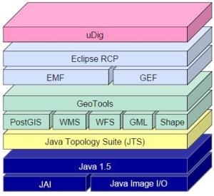
We’ve already taken a look at other open source tools in the GIS area, including Qgis and gvSIG, apart from non-free programs we’ve tested before. In this case we will do the same with User-Friendly Desktop Internet GIS (uDig), one of those who come in PortableGIS. The place where did it come from uDig is a construction from Refractions Research ...
Read More »Attach a map with an Excel table
I want to attach an Excel table to a map in shp format. The table is being modified, so I don’t want to convert it to dbf format, or put it in the geodatabase. It is a good exercise to kill the leisure of this holiday and, by the fly, take a look at ArcGIS 9.3 from the Acer Aspire ...
Read More »What is going to be in the Free GIS Conference of Girona
Three months after the beginning of the IV Conference, to be held in the 10 to 12 March, this is the proposal of what we might see there. IDE / OGC IDE Open Source: The way towards INSPIRE. Spatial data Infrastructure from Venezuela, an IDE made with100% free software. Integration of the WMS-C recommendation on pre-existing standards in the IDE. ...
Read More »SEXTANTE, gvSIG + 220 routines
As well as GRASS complements Quantum GIS, SEXTANTE does the same with gvSIG, keeping the specialty. These are the best efforts of collaboration between open source alternatives in the geospatial environment, searching to prevent unnecessary duplication. The gvSIG effort of maintaining vector handling with many CAD capabilities is complemented with everything that has been built in SEXTANTE after its abandon ...
Read More »gvSIG 1.9 stable has arrived. Hooray!
This week has been released the stable version of gvSIG 1.9, from which we had the RC1 in August and the Alpha version in December 2008. This version will possibly make history, because maturity is enough to promote it for municipal use, without being belittled by smallness made by ArcView 3x and not done by gvSIG 1.3. They have faithfully ...
Read More »Apply transparent colors in images
Many images have been cut from polygons, but in doing so, it has not been set a transparent color to the background and that’s why an uncomfortable black color appears. Or in other cases, we wish not be visible a range of colors; let’s see how to do it: With gvSIG. I’m using stable version 1.9, which download madness ended ...
Read More »gvSIG, what is going to be in the 5ths Workshops
It has already has been announced a preliminary version of what it could be in the fifth gvSIG workshops that will develop in the Events Centre of Valencia, from December 2 to 4, 2009. Much of the work presented is from Spain, although there are some experiences from Germany, Italy and there. It also calls attention some American environment projects ...
Read More »gvSIG: 21 CAD tools
A common weakness in specialty GIS programs is its limitation to construct data with the ease that offers CAD-oriented tools. Gradually, the gap is narrowing, although it is questionable whether the GIS has had an improvement in their ability to build or CAD have implemented variants such as Bentley Geospatial Map and AutoCAD Map. gvSIG 1.9 has made almost a ...
Read More »GvSIG Courses in Valencia
From the first quarter of 2010, the Florida University Central Training courses will be offering gvSIG, which to date has been provided as an adjunct to the Interior tourism specialist diploma courses. This course has a lasting of 20 hours over two weeks, and is aimed at professionals, technicians and officials who wish to enter the GIS field using a ...
Read More »Portable GIS, all from a USB
It has been released the 2.0 version of portable GIS, a simply wonderful application that can run the necessary programs for spatial information management using both desktop and web interfaces; through different devices like external drives, USB memory sticks or even digital cameras. What’s its weight? The installer file weighs 467 MB, but it takes at least 2GB USB free ...
Read More »Sinfogeo: GIS distance courses
Very few times we have seen an offer in the GIS area as the one offered by Sinfogeo. The opportunity is not only to learn but for specialists, which can track students and build online training manuals. Being online it can be taken from anywhere in the world, but are available in classroom (in Spain). They are not free, nothing ...
Read More » Autocad Software, Bentley Microstation, Gis Google Earth, Gis System Geomate Provides Services For Complete Gis Software And Solutions, Autocad Software, Autocad Courses, Bentley Microstation, Microstation Software, Gis Google Earth, Open Source Gis And More.


