It is perhaps one of the most valuable systematization products of Spanish -speaking environment under geospatial thematic. Not having this document at hand is a crime, as well as ignores this project before reading this Geomate’s article. It is likely that not in a publishing house will be found such a product in Hispanic environment, I dare to think beyond ...
Read More »OSGeo
36 themes of the Sixth Conference
From December 1 to 3 will be taking place in Valencia the sixth edition of the gvSIG Conference. This event is the best of continuous strategies that the Organization has pushed for the sustainability of software that continues amazing by its potential in the global market penetration. Little by little, free software has been taking valuable spaces in a niche ...
Read More »How Mapserver works
TRANSLATION NOTES: Please read some comments at the end of this post. Last time we talk about some criteria of why MapServer and its basic installation. Now let’s look at some of its performance in a mapping exercise from the Chiapas buddies (*). Where it is mounted Once installed Apache, the default publishing directory for MapServer is the OSGeo4W folder ...
Read More »Deciding for MapServer
TRANSLATION NOTES: Please read some comments at the end of this post. Taking advantage of a recent conversation with a Cadastre institution that sought with what to publish their maps, I summarize here the most important to return the item bailouts to the community. Maybe in time it’ll serve someone who wants to make a decision or ask for egeomate’s ...
Read More »uDig, first impression
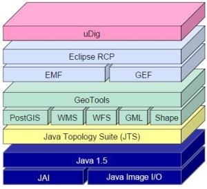
We’ve already taken a look at other open source tools in the GIS area, including Qgis and gvSIG, apart from non-free programs we’ve tested before. In this case we will do the same with User-Friendly Desktop Internet GIS (uDig), one of those who come in PortableGIS. The place where did it come from uDig is a construction from Refractions Research ...
Read More »eGeomate: Predictions 2010: GIS Software
TRANSLATION NOTE: Please read the comments at the end of the post to clarify the real meaning of some terms. ——– A couple of days, at the warmth of a stick coffee (Spanish Idiom: “café de palo” a kind of coffee entirely prepared at home without any electrical artifact) made by my mother-in-law, we did some hallucinations on marked trends ...
Read More »gvSIG, what is going to be in the 5ths Workshops
It has already has been announced a preliminary version of what it could be in the fifth gvSIG workshops that will develop in the Events Centre of Valencia, from December 2 to 4, 2009. Much of the work presented is from Spain, although there are some experiences from Germany, Italy and there. It also calls attention some American environment projects ...
Read More »gvSIG: 21 CAD tools
A common weakness in specialty GIS programs is its limitation to construct data with the ease that offers CAD-oriented tools. Gradually, the gap is narrowing, although it is questionable whether the GIS has had an improvement in their ability to build or CAD have implemented variants such as Bentley Geospatial Map and AutoCAD Map. gvSIG 1.9 has made almost a ...
Read More »GvSIG Courses in Valencia
From the first quarter of 2010, the Florida University Central Training courses will be offering gvSIG, which to date has been provided as an adjunct to the Interior tourism specialist diploma courses. This course has a lasting of 20 hours over two weeks, and is aimed at professionals, technicians and officials who wish to enter the GIS field using a ...
Read More »Portable GIS, all from a USB
It has been released the 2.0 version of portable GIS, a simply wonderful application that can run the necessary programs for spatial information management using both desktop and web interfaces; through different devices like external drives, USB memory sticks or even digital cameras. What’s its weight? The installer file weighs 467 MB, but it takes at least 2GB USB free ...
Read More »Generic web publishing tool for municipal mapping
This is a great work of Miguel Álvarez Úbeda, a final project to obtain Master of Science degree from La Coruña University. The objective of this project has been to propose a solution to the municipalities and communes, with which it can be done the storage, management and publication of cartographic information and others (not necessarily maps) that could have ...
Read More »gvSIG 1.9 RC1, ready to download
It is ready for download gvSIG 1.9 RC1, the first distribution of the candidate version (Release Candidate) from August’s Build 1243 of 313. The download took a while, because it was out of service initially gvsig.org, where builds are lowered, and then the available unzip and run version appeared as a corrupt file. But finally, here it is, for our ...
Read More »gvSIG: The hazards of this and other trades
The way free tools have matured is interesting, some years ago, talking about free GIS, sounded like UNIX, in a geek voice and with a level of distrust or fear of the unknown. All that has changed much with the diversity of solutions that have full-grown not only in the construction of routines commonly expected but overcrowding innovative strategies, testing ...
Read More »Who Moved My Cheese?
I like Geoinformatics so much, cause besides being a magazine with a great layout appeal; the contents are very good in geospatial. Today has been announced the release of April, where I have taken some texts highlighted in red to motivate a luscious reading. In earlier versions I did a summary for them, today I’ve taken as the post theme, ...
Read More »Connect Manifold with Open Street Map
Some time ago I spoke that Manifold can connect to Google, Yahoo and Virtual Earth. It has now emerged the connector to link with Open Street Maps (OSM), which incidentally has been developed in C# by a forum user called Jkelly. The news appeared this week in the Manifold’s forum, where were both loaded the .dll to connect as the ...
Read More »Geomatics, further developments
Apart from the published magazine few days ago by Geoinformatics, there are some other issues, published this month in its portal, that worth sharing. Although some of these ads look like (Spanish idiom:‘tienen pinta’) being sponsored; they contribute a bit to the progress that technology is having now and sets the standard towards what we expect for the rest ...
Read More »gvSIG as an alternative for municipalities
This week I’ll have a meeting with project’s technicians which are considering gvSIG as an alternative to be implemented in municipalities where they’re running a territorial ordering project that comprises part of Central America. In Latin America we hear different experiences about gvSIG’s use; in this case I want to mention one of them occurred in Guatemala, possibly the first ...
Read More »Convert kml to dxf files
A while ago there was a practical application from Zonums’s friend that made this role without much hindrance. Unfortunately, the friend was very strategic to create an expiration date for its solution, so that if you open it now says it is expired; it is very likely that he sell the license … blah, blah, blah. Well, what we want ...
Read More » Autocad Software, Bentley Microstation, Gis Google Earth, Gis System Geomate Provides Services For Complete Gis Software And Solutions, Autocad Software, Autocad Courses, Bentley Microstation, Microstation Software, Gis Google Earth, Open Source Gis And More.


