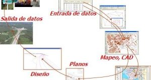
Home > ArcGIS / ESRI

ArcGIS / ESRI

The 5 States of Matter

TRANSLATION NOTE: Please read the comments at the end of the post to clarify the real meaning of some terms. Dear friends, I would like to drop a poem of the kind that stir me nostalgic, but it will be another day. For now I’m enjoying a holiday that cost to come, here some superficial details. My daughter had her ...

Read More »

eGeomate: Predictions 2010: GIS Software

TRANSLATION NOTE: Please read the comments at the end of the post to clarify the real meaning of some terms. ——– A couple of days, at the warmth of a stick coffee (Spanish Idiom: “café de palo” a kind of coffee entirely prepared at home without any electrical artifact) made by my mother-in-law, we did some hallucinations on marked trends ...

Read More »

Nothing spatial ArcGuments

The matter is that the first time I saw you, the impression I took was that the plot of your style was outside my reach; maybe because the first version I saw was very clearly arranged to your style; so, since those days I got thinking that it was geopdf. Then, I mistook with the basic rgb of your labels, ...

Read More »

Comparative of topography GIS software

Wouldn’t anyone like to have a table that compares different types of GIS software with topography’s features in order to make a decision on purchase? Well, such a thing exists at Point of Beginning, and it includes not only popular use software such as Autodesk, ESRI, MapInfo or Intergraph but also equipment manufacturers like Topcon, Leica and Trimble. There are ...

Read More »

Sinfogeo: GIS distance courses

Very few times we have seen an offer in the GIS area as the one offered by Sinfogeo. The opportunity is not only to learn but for specialists, which can track students and build online training manuals. Being online it can be taken from anywhere in the world, but are available in classroom (in Spain). They are not free, nothing ...

Read More »

TopoCAD, more than Topo, more than CAD

TopoCAD is a basic but comprehensive solution for surveying, CAD drawing and engineering design, although it does more than that in a development that has taken more than 15 years after his birth in Sweden. Now it is all over the world in 12 languages and 70 countries but does not seem to have achieved a higher market segment. TopoCAD ...

Read More »

MapInfo: Yesterday, today and perhaps tomorrow

MapInfo is software that has been popularized on a regular basis as a competitive alternative to the ESRI dominance. Much has been written about this tool, I want to dedicate this post to a review on its trend than on its capacity, which according to 2008 Daratech study appears in seventh place in terms of sales in 2008 and sixth ...

Read More »

List of Software I reviewed

I spoke recently about what means in statistics to talk about software, specifically 11 programs which represents 50% of the visitors coming by keyword visits. It is difficult to give recommendations of which software is better, because it depends on the context (and the money) conditions, the more I can aspire is to write and give my impressions; to enable ...

Read More »

Why we have to thank neogeographers like Google

This is the name of Eric Van Rees interview conducted with the leading men of three outstanding companies in Geoinformatics technologies: Jack Dangermond, ESRI President Richard Zambuni, Director, Bentley Geospatial Line Ton de Vries, CEO of Bentley Cadastre line and land development Halsey Wise, Intergraph President and CEO The document is interesting, and comes at a time when evolution in ...

Read More »

Hazards of my ArcGIS course

TRANSLATION NOTES: Please read some comments at the end of this post. Before telling them he was going to develop training in the use of ArcGIS 9.3, with a half enormous mode for the distance, my short time and students’ occupations. Now I leave some conclusions: About the methodology: If only everything were so simple. If it were to give ...

Read More »

Videos for learning Manifold and ArcGIS

ScanControl is a website with much to show, but what more drew my attention is that it has presented a demo videos series first of ArcGIS, something not surprising as it’s a highly popularized tool; but what is really interesting is that it also presents a series of videos of Manifold GIS, a tool that is growing but of which ...

Read More »

Top 60, the most searched of egeomate 2008

Here is the list of the 60 most popular words in egeomate (geofumadas in Spanish) in this 2008 year: 1. Own brand (1%) This is the keyword for which have reached more visits, usually used by those who already know the blog, who did not attend nor have read rss in their favorites, and not to write the crazy url ...

Read More »

2 good egeomates and others at the flight

Preparing to take my daughter to the dentist, and spend a long weekend I’m leaving some interesting links. The first ones are two interesting egeomates (Spanish Idiom: “geofumadas”, in this case ideas) that I recommend to look carefully, and then some contents for those who are seeking healthy readings on Friday night Blom, Visual Inteligence: Pictometry is an interesting product ...

Read More »

Converting shp to kml… and an all-out smoke

Fdo2Fdo is an interesting application that serves not only to convert shape format files to kml’s as it’s announced in this post in a poorly way. For now, it becomes an alternative after shp2kml’s death which, according to its creator’s rules, has apparently expired Seeing its capabilities it turns in a great surprise considering that it’s a tool for free. ...

Read More »

Geomatics, further developments

  Apart from the published magazine few days ago by Geoinformatics, there are some other issues, published this month in its portal, that worth sharing. Although some of these ads look like (Spanish idiom:‘tienen pinta’) being sponsored; they contribute a bit to the progress that technology is having now and sets the standard towards what we expect for the rest ...

Read More »

ArcGIS and Manifold GIS comparison

It’s just a titanic work which has made by a Manifold’s user called tomasfa and that has been uploaded to that tool’s forum. It reminds me that Arthur J. Lembo’s work when he did a very systematic job of how to do the same routine with ArcGIS and Manifold. More than the comparative sense I was struck by the number ...

Read More »

Manifold GIS creating layouts for printing

In this post we will see how to create an output map or what we call layout using Manifold GIS. Basics To create a layout, Manifold allows you to keep nested in a dataframe or a map as it is known, although it may be within a folder or associated with a layer or another Manifold object called parent. You ...

Read More »

The best of the gvSIG’s 4th Journeys…

Many people agree that the best achieved in this recent days’ journeys was the allusive event’s magazine, which represents a great job, not only for the regarding content but for its fancy graphic design.  For those who received the printed format, certainly it represents an invaluable one-piece collection, just the same as those Obelix’s comics saved in an old but ...

Read More »