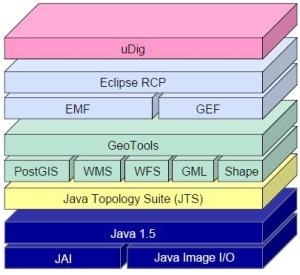
TRANSLATION NOTES: Please read some comments at the end of this post. A few days ago I started a development on .NET, with which I hope to settle the Bentley Map’s limitation with its Geospatial Administrator. For this, I caught an old pupil with which we began to egeomate with xfm when he came out from the Comal(*); tasting a ...
Read More »Tag Archives: dgn
Failure cursor, Bentley V8i
I have already reached PowerMap V8i Select Series 1 (8.11.05.19) which brings some interesting news. PowerMap, like PowerCivil PowerDraft and do not occupy a MicroStation license, but it is included as a runtime for a price quite low compared with Map + Bentley Microstation. So it runs like an application developed by oneself on Microstation’s API with all features except ...
Read More »Bentley Map, could it be more difficult?
MicroStation Geographics step to Bentley Map suppose an improvement on features the first one tool did, and naturally try to make an effort on gaining users from other solutions such as ArcView, MapInfo and now a whole list of programs low price and open source. Just now that I am working with a regular-sized municipality which wants to implement a ...
Read More »Generating contours with ArcGIS
Making land surveying with a total station, apart from having pinpoint accuracy, it also may be useful for other purposes, given that you have the elevation of each point. In this case, let’s see how generate contour, which was already sawn with AutoDesk Civil 3D, Bentley Geopak and Manifold GIS, so for educational purposes, in this case we will do ...
Read More »2 egeomates on the fly and 6 links
Long trip, for three days I have been touring with succulent creoles meals. Finally back, many unread mails and the new 12.2-megapixel Kodak camera going very well. Here I leave some readings and news of interest: Bentley extends interoperability to FME. Very interesting, Bentley Map has integrated the chance of interacting data via ETL from Safe Software. With this, it ...
Read More »ArcMap: Import data from Microstation Geographics
Sometime we talk about that since Geographics you can export / import data with ESRI, creating shp files. But if you have installed ArcGIS, the interoperability extension has very good features, let’s take a look: 1. Activate the extension. This can be done with tools > extensions and here we activate Data Interoperability extension. The tool is in ArcCatalog, but ...
Read More »TatukGIS Viewer… a great viewer
For now is one of the better (if not the best) CAD / GIS data viewers I’ve seen, practical and free. Tatuk is a product line born in Poland; just a few days ago it was announced TatukGIS Viewer version 2. Other viewers If we value the free programs of other brands, provided to view data you will find at ...
Read More »uDig, first impression
We’ve already taken a look at other open source tools in the GIS area, including Qgis and gvSIG, apart from non-free programs we’ve tested before. In this case we will do the same with User-Friendly Desktop Internet GIS (uDig), one of those who come in PortableGIS. The place where did it come from uDig is a construction from Refractions Research ...
Read More »Bentley Cadastre: differences with Bentley Map and Power Map
From MicroStation Geographics in 2004 it was launched the project known as XFM, which within the same V8 dgn format included XML capabilities. After the 8.9 version known as XM Bentley discontinued, Geographics launches Bentley Map, a different smoked regarding the handling of data, but with the same logic operation. Migrating is now indisputable, for this I make the difference ...
Read More »Geofumadas: 48 black and white
Closing this year, which has been of many extra flavors, it’s left for me to wish you a happy 2011 in which we have much to do. For those who had read in this blog more than 299 entries, this post will be out of site, but for the others there almost 50 lines that define the art of egeomate ...
Read More »eGeomate: Predictions 2010: GIS Software
TRANSLATION NOTE: Please read the comments at the end of the post to clarify the real meaning of some terms. ——– A couple of days, at the warmth of a stick coffee (Spanish Idiom: “café de palo” a kind of coffee entirely prepared at home without any electrical artifact) made by my mother-in-law, we did some hallucinations on marked trends ...
Read More »Geographics: Installing a local Project
TRANSLATION NOTE: Please refer to the end of the post for knowing more about some Centro American Dishes and drinks. ——— The case occurred in a project where the central database was Oracle, but for doing cadastral maintenance at municipalities level or public exhibitions features base was required in order to edit maps while offline. How it was done Only ...
Read More »Caceres’ GIS
This is one of the projects that became a finalist for the award of the Be Inspired 2009 in the category of Cadastre and Land Development. They also made a presentation which was in charge of Luis Antonio Alvarez and Faustino Cordero, with a very good PPS presentation, videos and also a printed map. The day of the award I ...
Read More »I-model, the new Bentley bet
For a moment I had my doubts, if Bentley was talking about a new format to replace the dgnV8, then, I thought it was a kind of compressed format like the kmz with Google Earth kml. Many months ago I did a post, wanting to assume the meaning of the “i” in the V8i, after the presentation made at the ...
Read More »Global Mapper, working with dgn format
Reading the dgn format is a standard in most of GIS or CAD programs, but several of these software (including Manifold GIS and gvSIG) are still reading the V7 format. AutoCAD and ArcGIS have already achieved it. Let’s see how Global Mapper does it: 1. Reading dgn V7 It is interesting that files can be in a compressed archive of ...
Read More »Difference between images of Google Earth Pro and Google Earth free
There are many myths about it, since some who claim to see the female neighbor bronzing nude to those who find no difference between the versions. Let’s see if we speak from this topic with a couple of examples: 1. Yes, there is difference in resolution What happens is that the difference in resolution is for output purposes, if you ...
Read More »TopoCAD, more than Topo, more than CAD
TopoCAD is a basic but comprehensive solution for surveying, CAD drawing and engineering design, although it does more than that in a development that has taken more than 15 years after his birth in Sweden. Now it is all over the world in 12 languages and 70 countries but does not seem to have achieved a higher market segment. TopoCAD ...
Read More »Quantum GIS, first impression
If gvSIG friends fulfilled their promise, next Monday July 27th we will have the 1.9 stable version. So far the test has been great, according to the perceived volume of distribution lists. While waiting on Monday, by which time I hope to have the satisfaction of congratulating the performance of speech, at the cost of surely sleeplessness developers, let’s take ...
Read More »