AutoCAD by itself only brings many features for coordinate management or tables’ creation from starting points. What Civil 3D makes, but basic version does not, and therefore when we go working coordinates generated by a total station, GPS or from doing stakeouts, we must resort to macros watered by there.
But XYZtoCAD is not a simple macro, is a tool built on logical work, with upgrade online option. What happens is that, as being free, anyone can belittle its potential in these days when opensource being better than brands, costs to position it.
Install XYZtoCAD
Executable file is downloaded from programacionautocad.com, and then it must be run and followed the wizard. By the end asks us about what AutoCAD installation we want to enable. In some cases, the final step does not happen and it usually happens by having a wrong instantiated license in system log, –or pirated, as you want to call it–

In the event of problems installing, CADnet friends have suggested the following:
1. Open AutoCAD
2. Type in the command line: netload and then do enter
For AutoCAD 2010 -2011 select file
c : cadnet xyztocad app R18 xyztocad.dll
For AutoCAD 2007-2008 – 2009 select file
c : cadnet xyztocad app R17 xyztocad.dll
As we see, this tool runs on versions from 2007 to AutoCAD 2011 and as being built with .net we can be consider it will also run on AutoCAD 2012 that in a couple of months will be released.
I take this opportunity to comment that AutoCAD 2012 can be downloaded for free, from this link, for now in beta version for purposes of testing; it is only need to sign up.
 Activate XYZtoCAD menu
Once installed, is activated in the command line by typing
zxc
When doing enter, it should appear on the top bar a new menu as shown in the picture.
If you no longer want to see the menu, the command is inactivated with the command
 zxdel
zxdel
It is likely that when version is installed a new one already exists; so you can upgrade using the command
zxu
Import Excel points
For this task this application makes wonders in a single panel. A txt file is selected, next, the order in which data are; if you want to place points or blocks. We need to add also point size, layer where data will be saved and it’s ready.
I give my respects to CADnet.es’s friends whom had got a cool tool with this toy.
There are buttons that do not seem are placed there as view data button that allows to preview the table being imported. It’s also point format selecting option from an existing one.
 And once points have been drawn, a button is activated for table’s generation. It is required to indicate upper left corner’s location, and then accept table style; so it raises several tables in case they are many points (100 points per page) and with a click generates a table with the ID, X coordinate, Y coordinate, elevation and angle at next point. It’s a great tool for stakeout, though I have my distrusts about this data angle usefulness.

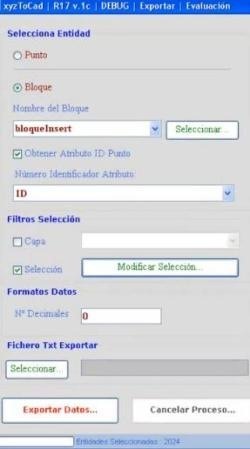
Export points to txt
It’s the same in conversely way. It can be selected from blocks or dots, from a layer or entities selection. Then it must be told how list must be numbered, number of decimal places, where to store the txt file and that’s all.
Sure, a txt file can be opened with Excel, just not from browser, but going into Excel and choosing ‘all files’ option. Then the wizard takes us step by step until it displays as a table. Similarly, table can be saved as comma separated text or tabs, taking care it’s placed on the first page and do not have merged cells or such rare things like this.
It struck me a button that stops process, this action may be necessary if it will work with a very large amount of points or routine hangs.
Well, there it is. The best I’ve seen for using in topography free applications for AutoCAD.
Here you can see an uploaded video in Youtube running

 Autocad Software, Bentley Microstation, Gis Google Earth, Gis System Geomate Provides Services For Complete Gis Software And Solutions, Autocad Software, Autocad Courses, Bentley Microstation, Microstation Software, Gis Google Earth, Open Source Gis And More.