TRANSLATION NOTES: Please read some comments at the end of this post.
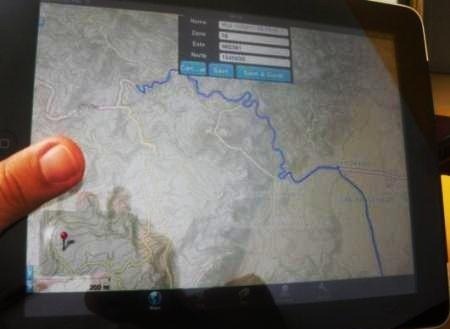
 I’ve downloaded an application for the iPad that has left me more than satisfied in my need to do GPS tracking and then view it online or with Google Earth.
Gaia GPS is an application that costs just $ 12 but is very functional for mobile phones that have Apple’s operating system or Android. Its capabilities go beyond capturing a route, because in addition to everytrail.com can display photos, routes on Google Maps and even export to GPX for use with a conventional browser and kml for viewing in 3D on Google Earth.
Let us review in detail what can be done with this toy.

1. Navigation with the Ipad
The application is just for downloading, once installed allows various routines nearly enough for what I had in my expectations:
- You can create routes, indicating when starts, when to pause the capture and where to continue.
- In the background can be displayed Open Street Maps or topographic maps with global coverage.
- It can be displayed more than 10 million known points, such as mountains, river crossings, communities and other points of interest.
- The GPS does not depend on whether there is a connection to the Internet; it continues capturing images while the images deployments only show what is in cache.
- To prevent this, you can save an area as a mosaic of images for tiled deployment even offline.
- Stores along with the route a graphic and statistical account of each point of capture, which can be seen in real time; with data such as geographical or UTM coordinates, current speed, the journey average speed, elevation above sea level, distance traveled, and so on.
With the iPad experience is much better than with phone, because of deployment size and ease of fingers use to interact. Then, the route can be stored and redeployed for analysis at any time.
The best from everything shown can run in the background, so you can go working on another feature with the iPad or being at hibernating state. Activated at any time, and stops its run or starts a new one without much memory or battery consumption.
2. Display on Google Maps.
For this, you must register at everytrail.com or even by logging with your Facebook login. Then, from the iPad the route is taught and the export option is chosen; it is stored as a new file on my trips, they can be public or private.
Here’s the kicker, it can be displayed using Google Maps layers at the background, either as satellite view, terrain, or hybrid map.

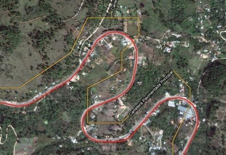
The red line is the path captured. The graph shows in blue the profile rail travel and in orange profile the journey speed in miles per hour. Also the abstract, in that journey I did that last 13 kilometers in 14 minutes and a decline of nearly 400 meters.
This graphic, can even be run as a video as it’s shown below, although it appears largest online.
Precision of the iPad’s GPS?
Not so bad, just like any browser. Goes between 3 to 6 meters, it can be seen clearly in the picture below, although it would be test while capturing in a static mode because there was on the vehicle at 50 kph of speed and in some cases the difference was tested by changing capture times by distance or seconds. Pretty nice (*) on the road, let’s see the great difference with the lines that Google has in most non-urban areas of Latin American countries.

Of course, not all cases fall as well with the Google Earth photo, not because the device lose precision, but because Google’s image presents movement between 10 and 20 meters in far rural areas from big cities or with rather irregular topographies where a simple used land model affected its georeferencing.
Edit and export to other formats
Online it allows adding new routes, even clicking on the map you can edit by dragging vertexes; another great feature is that you can generate from several routes a new one that contains all of them. It’s not so bad since you can send GPX, in order to mount it on other devices such as Garmin, Magellan, SPOT Satellite Messenger, Blackberry, etc. The page also supports uploading GPX files caught with any GPS navigator.
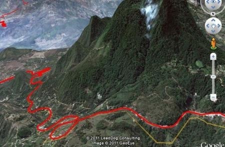
In addition, it can be exported to kml, which can be visualized in 3D.

Nothing bad, sure there are other applications doing the same but this seems the best, in complement with the web page functionality that solves the need to upload, create, edit or display online gpx file of waypoints or tracks type.
TRANSLATION NOTES:
(*) Chulo: it’s an idiom commonly used when someone or something is pretty or pretty nice.
 Autocad Software, Bentley Microstation, Gis Google Earth, Gis System Geomate Provides Services For Complete Gis Software And Solutions, Autocad Software, Autocad Courses, Bentley Microstation, Microstation Software, Gis Google Earth, Open Source Gis And More.
Hi there colleagues, pleasant paragraph and good urging commented here, I am really enjoying by these.
Feel free to surf to my web blog – garmin gps nuvi 1300lmt