Home > Tag: kml

Tag Archives: kml

TopoCAD, more than Topo, more than CAD

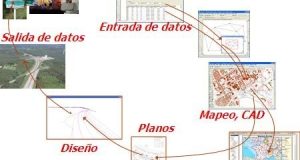
TopoCAD is a basic but comprehensive solution for surveying, CAD drawing and engineering design, although it does more than that in a development that has taken more than 15 years after his birth in Sweden. Now it is all over the world in 12 languages and 70 countries but does not seem to have achieved a higher market segment. TopoCAD ...

Read More »

Google Earth improves the way to notice its upgrade

Every two months or so Google Earth has been updating its images, but the way of notifying has been only mentioning the country, the nearest city, and even a couple of times it said the upgrade in this regard: Look, we have updated images, but truly we don’t really remember where, so review on their own where the lightning was… ...

Read More »

KML Manager, too much for 12 Euros

Small solutions always caught my attention; I think that if they don’t exceed $ 50 and solve what a great program doesn’t, they should be lucky. Today I want to show you KML Manager, a tool that just goes by 12.95 euros, it weighs less than 1 MB but let’s see what is within this egeomate (Spanish Idiom: “geofumada” which ...

Read More »

Touche Google Maps Extractor

A few years ago Google began mapping business; in that project Google was even paying $ 10 for every business to be georeferenced. Now they have a base that can be deployed both in Google Maps and Google Earth. Now imagine that there is an application that, with only giving a location and a radio distance can extract for us ...

Read More »

Quantum GIS, first impression

If gvSIG friends fulfilled their promise, next Monday July 27th we will have the 1.9 stable version. So far the test has been great, according to the perceived volume of distribution lists. While waiting on Monday, by which time I hope to have the satisfaction of congratulating the performance of speech, at the cost of surely sleeplessness developers, let’s take ...

Read More »

Display a georeferenced image in Google Earth

TRANSLATION NOTES: Please read some comments at the end of this post. Let’s suppose I want to show in a georeferenced way an image available on a website. I had already spoken of this before, but in this case I would like to project a map that is not on my hard drive but online. This is the case of ...

Read More »

Where to find maps in vector format

Find maps in vector format of a given country could be the urgency of many. Reading Gabriel Ortiz forum I found this link which is interesting because it not only provides maps in .shp format but in kml, grid and mdb. It’s gData, a service promoted by the International Rice Research Institute, is free and seems to have information from ...

Read More »

3 blogs and 8 egeomates on the fly

I’ll be by Houston attending training and at the same time I’ll be resting from this world’s pressures whose kml format seems to lose its simplicity. The month brings much appreciated birthdays, first it will be two years of hardly geosmoking, and so it goes … this month will goes on travelling I recommend 3 blogs that surely will have ...

Read More »

Earthquakes in Google Earth

A few days ago I spoke of the tectonic plates that USGS has prepared for display in a simple kml file of 107 k, and with this we must be acknowledged that Google Earth has changed our lives for what it’s possible seeing with the simple intuition of those who are not experts in the topic. This earthquakes layer can ...

Read More »

How to place a video on Google Earth

I get a question where someone wants to upload a video to Google Earth, I understand you are looking for show routes and attach a video. Let’s see something you can do and that could apply our Mexican friends, is very similar to placing a photo. Embedding a Youtube video Assuming that I want to indicate in the story “Eyes ...

Read More »

Hazards of my ArcGIS course

TRANSLATION NOTES: Please read some comments at the end of this post. Before telling them he was going to develop training in the use of ArcGIS 9.3, with a half enormous mode for the distance, my short time and students’ occupations. Now I leave some conclusions: About the methodology: If only everything were so simple. If it were to give ...

Read More »

How to upload a kml to Google Maps

Several days ago a friend sent me a question regarding on uploading maps that can be deployed in Google Maps without being putting with the API here I dedicate a while to do so. 1. Create a kml A kml can be created almost any mapping program, it can be ArcGIS, Manifold, Bentley Map, GvSIG or AutoCAD Map. You should ...

Read More »

2 good egeomates and others at the flight

Preparing to take my daughter to the dentist, and spend a long weekend I’m leaving some interesting links. The first ones are two interesting egeomates (Spanish Idiom: “geofumadas”, in this case ideas) that I recommend to look carefully, and then some contents for those who are seeking healthy readings on Friday night Blom, Visual Inteligence: Pictometry is an interesting product ...

Read More »

Converting shp to kml… and an all-out smoke

Fdo2Fdo is an interesting application that serves not only to convert shape format files to kml’s as it’s announced in this post in a poorly way. For now, it becomes an alternative after shp2kml’s death which, according to its creator’s rules, has apparently expired Seeing its capabilities it turns in a great surprise considering that it’s a tool for free. ...

Read More »

Digital terrain model in Google Earth

Valery Hronusov is the kml2kml application creator; it is interesting that today has published a note in which Google recommends it, strange but not so, knowing what makes this application that only weighs 1 MB. Some time ago I talked about how to do something like this with AutoCAD, and also with ContouringGE. Let’s see how this application works on ...

Read More »

Convert kml to dxf files

A while ago there was a practical application from Zonums’s friend that made this role without much hindrance.  Unfortunately, the friend was very strategic to create an expiration date for its solution, so that if you open it now says it is expired; it is very likely that he sell the license … blah, blah, blah. Well, what we want ...

Read More »

egeomates on the fly, January 2009

Gentlemen, these days are with too much work and very few time to complete all tasks (Spanish Idiom: “estos dias son de correr” ), between the end of the operational plan for this year, pay off last year balances and socialize with mayors the scope of what it implies to set up cadastral values in a political year … whew! ...

Read More »

GvSIG 2, first impressions

In the course we decided to try the new GvSIG version, which although is not yet declared stable, it can be downloaded different builds to see what happens. I downloaded the 1214, and even I hoped to prove the functionality of point and line symbols as xurxo told me, apparently I have to try the 1218. Here I left you ...

Read More »